Diversions
/
Trip Report
Appalachian Gravel Growler (Part I)
We plan and set off on our second multi-day bikepacking trip, this time through Western North Carolina.
Total Distance
176 miles
Elevation Gain
15,696 ft.
Conditions
1 hurricane
A Well-Laid Plan
Not long after we finished a trip through Ohio in late June 2020, Frances and I began dreaming about our next multi-day bike trip. Weekend jaunts were plenty fun, but they didn’t quite scratch the same itch. We live just a couple hours from Pisgah National Forest, which covers more than half a million acres and features an extensive network of forest roads, so setting our sights close to home for the next trip just made sense. This is a story of that trip. It’s a story of writing checks my legs couldn’t cash (again), recalculating a route over and over again, and having someone with whom you can ride through the best and worst times.
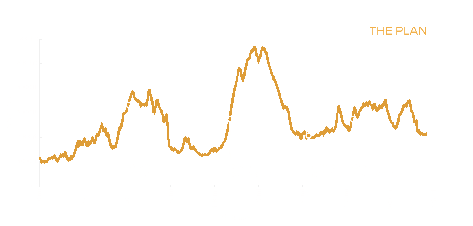
I’d eyed the Appalachian Gravel Growler route from bikepacking.com for several years and it seemed like a good fit for our second annual pandemic-packing trip. So named because it snakes through Western North Carolina close to many local breweries, the Appalachian Gravel Growler links up a lot of places that were already familiar to us. Beginning in Morganton, the route passes through the Wilson Creek Wild and Scenic Area, skirts Linville Gorge, tackles some monster gravel climbs up to the Blue Ridge Parkway, and visits Asheville before ending in Brevard, a town that may still be unknown to most tourists flocking to the region but has become a major biking destination. It amounts to more than 22,000 feet of climbing in just over 200 miles.
If you’re not regularly tackling routes like this one, those numbers can be tough to comprehend. I knew that was a lot of climbing, but was it too much? If we covered the route in five days, we’d need to climb about 5,000 nearly every day. We’d done that on a few day rides in the mountains, so it was possible to imagine doing so a few days in a row with loaded bikes would be tough but feasible–an ideal balance.
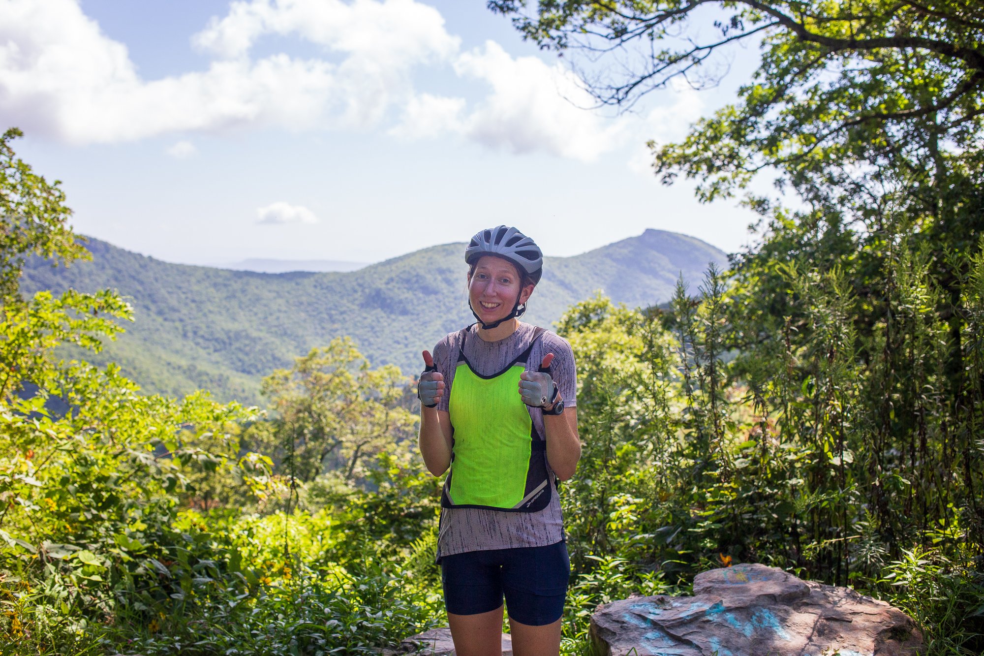
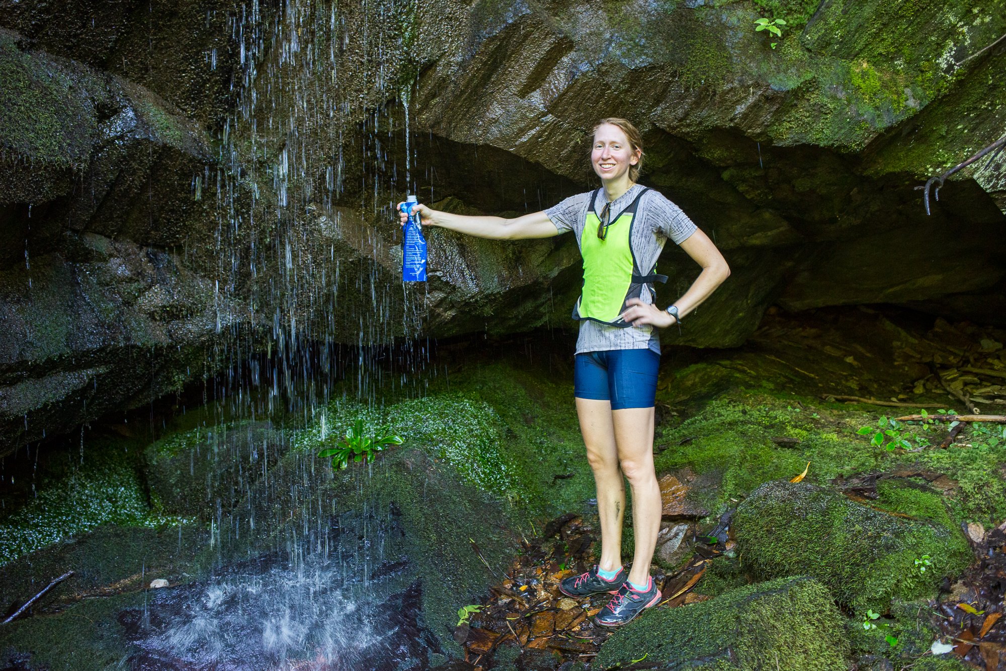
The planning began. We had a great head start with the published route, but I still pored over maps, virtually drove down roads on Google Street View where possible, cross-referenced information with the U.S. Forest Service, and lurked on Instagram for recent geotagged photos to get a better idea of conditions. To me, this is all part of the fun. All the planning doesn’t really spoil the trip, but I’ve learned that it instead allows me to enjoy it. Nothing will go exactly as planned, I’ll still be surprised, and the beauty to be experienced by immersing yourself in nature for the better part of a week is beyond what any of the photos I’d viewed can capture. As far as gear went, the choice of bike was easy for us. We’d take the same steel all-road touring bikes we’d ridden on last year’s trip: my Kona Sutra and Frank’s Rove ST. I had recently completed the conversion to a 1x12 drivetrain and tubeless tires on my Sutra and was excited to find out how it handled. I’d also get the chance to use my custom Rockgeist framebag that was delivered just after last year’s Ohio trip. With the promise of a few short technical sections, Frank took a different approach from our last trip and swapped her rear rack and panniers for an Outer Shell seatpack, half framebag, and Swift’s new-ish Catalyst bag, which fit well between the drops of her narrower handlebars. We would carry a camping setup for most nights, but some resupply points along the way and an Airbnb booked in Asheville allowed us to keep our gear minimal.
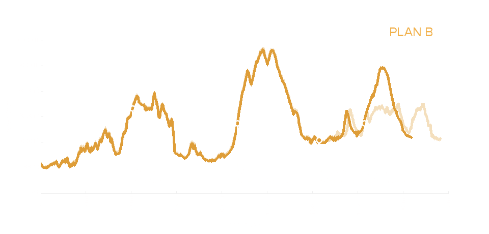
Just a couple weeks before we set off, Tropical Storm Fred made its way through Western North Carolina. The storm caused significant damage throughout the Caribbean and the Southeastern U.S., claiming six lives in North Carolina. With the mountainous topography, the impacts of heavy rains and flooding were severe in some places and virtually non-existent in others. While the impact to our recreation ultimately felt trivial, I closely followed updates from the Forest Service to understand whether we’d be able to do the ride at all. After several days, it became clear that most of the route was unimpacted but the end near Brevard would need to change completely. With bridges washed out and significant treefall, some highways and several forest roads were closed, including those we had planned to take on the final day. We’d need to ride a little more pavement, but could finish with a day on a particularly scenic stretch of the Blue Ridge Parkway and a meandering descent to town beside the Davidson River–it felt like a pretty good plan B.
Day 1
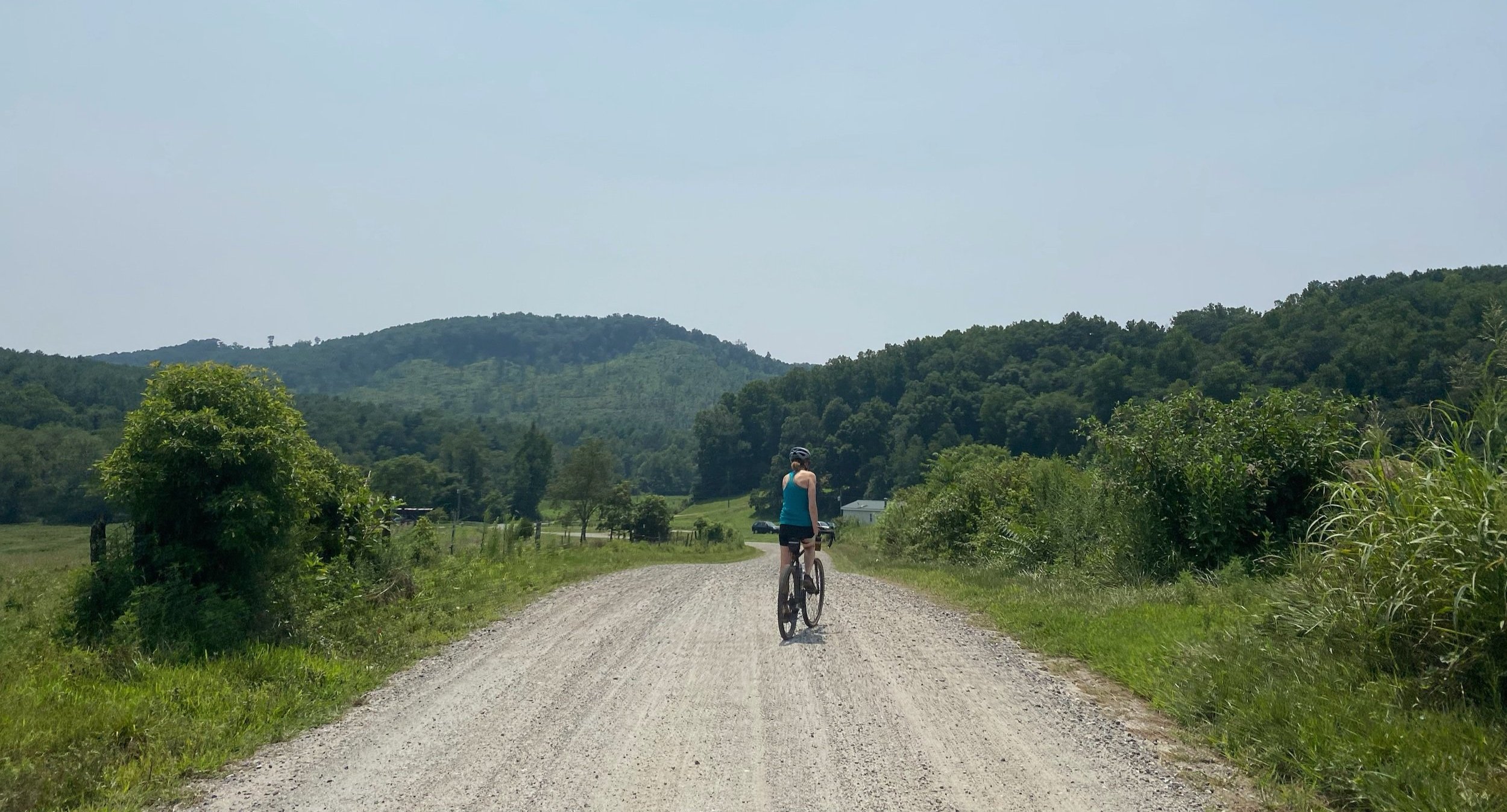
Finally, the time arrived. We left our car in Brevard and shuttled to the start with Michael from Overmountain Cycles in Morganton. The published route technically begins at Fonta Flora’s Morganton brewery, which sits next door to Michael’s shop. As someone who’s ridden the route forwards and backwards, he offered some last-minute beta and wished us well. It was well into the morning now, but the town was still quiet and we saw few cars as we navigated to the greenway that’d lead us out of town toward some iconic gravel stretches. The highlight of the day was Maple Sally, an 18-mile roller coaster that feels endless. That never-ending feeling can be amazing, but began to lose some of its charm as the afternoon passed. We planned to take a break at Betsey’s Ole Country Store in Mortimer, a bit of an oasis in the Wilson Creek area, before making a final sustained climb for the day up Pineola Road to camp. I’d stopped into the store several times on rides in the area, but had never approached it from the east and the point on my GPS seemed for a while to magically maintain its distance from us. Eventually, we coasted into the intersection where Betsey’s stands and found a sunny spot in the grass to enjoy some chips and a Coke before continuing on.
I didn’t feel especially anxious about getting caught by the dark on the final leg of our first day. After all, there was little to do but set up camp, eat, and sleep once we finished—things that are all easy enough, and one even better, to do in the dark. Frank wisely suggested we start moving again, though, before our legs determined they were done working for the day. The nearly 10-mile ride up Pineola contained a final couple thousand feet of climbing in the form of one consistent, gradual grade. Frank seemed to get stronger at the end of the day, perhaps motivated by the desire to find a suitable spot to settle, while I began to deteriorate. I had entered the land of type II fun. That wasn’t a foreign experience on the first day to me—we encountered a hike-a-bike through shoulder-high grass on the first day of last year’s tour—but I did begin to doubt my ability to complete our itinerary for the week. At one point, while pausing and waiting for me to catch up, Frank spotted what was likely a bobcat crossing the road in the distance behind me. As we neared the top of the road, we found a suitable spot to pitch our tent near a group of car campers. Despite our neighbors a hundred yards away, the earlier bobcat sighting and fresh bear tracks in the mud near our camp reminded us that we were in one of the wildest places in the state. I put aside any worries I had about the rest of the trip and enjoyed the time I had in this place with this human I love.


